

Introduction
This article shall describe a very simple approach to working with a GPS device within the context of a C# application. This article does not address how the GPS device works or everything that can be gleaned from the NEMA 0183 string outputted from most GPS devices; rather, the article is intended for those just interested in getting present position from a GPS and using that point to do something interesting like show you where you are on a map.
Nothing exotic or expensive was used in this project; the GPS source was a provided by my Garmin eTrex Legend handheld GPS purchased for about $100.00 (a nice little GPS but not the high end to be sure). Since my laptop provides no male serial ports, in order to connect the device I needed an adapter; for this I opted to purchase a Belkin Serial Port to USB adapter (an F5U109) which works great; the cable used to connect the device to a computer was provided with the device.
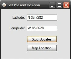
Figure 1: Getting Present Position from the GPS
To make matters more interesting that just outputting present position, I provided the means to map the point directly into Google Maps using the query string accepted on that site populated with the current latitude and longitude of the device. I had published something similar on C# Corner a while back but without the GPS interface provided. Interestingly enough (but not surprising), if you compare the present position of the device as shown on the map versus the physical address when plotted on Google Maps, you will likely note that the GPS position is more accurate than the geocoded physical address.
NOTE: In order to retrieve present position from the GPS device, it is necessary to configure the device to output the NEMA 0183 complaint string. Refer to your owner's manuals to determine how to set that up with whatever device you may be using.
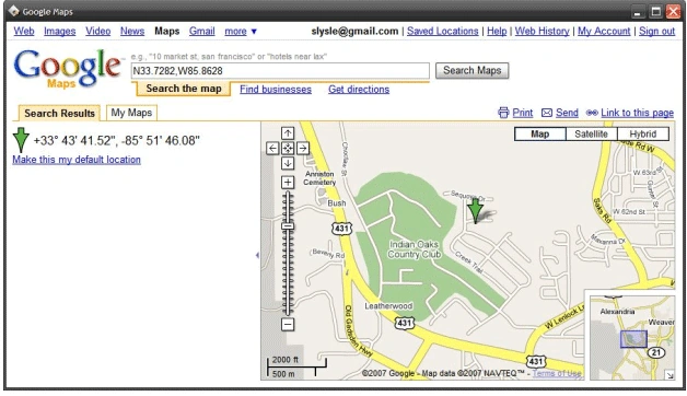
Figure 2: Google Maps Showing the Plotted Present Position
Getting Started
The solution contains a single Windows Forms project called "ReadGPS" which was written in C#; the application contains two forms (frmPP.cs, frmMap.cs) and, aside from the Program.cs file, all of the code necessary to drive the application is contained in those two form classes.
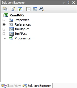
Figure 3: Solution Explorer with the Project Visible
Code: Main Form (frmPP.cs):
All of the code necessary to derive present position from a GPS device is contained in this single form; the form shall be described entirely in this section.
The code for this form class begins with the following:
using System;
using System.Collections.Generic;
using System.ComponentModel;
using System.Data;
using System.Drawing;
using System.Text;
using System.Windows.Forms;
using System.IO.Ports;
namespace ReadGPS
{
    public partial class frmPP : Form
    {
Following the imports, the declaration of the namespace and the form class, the next order of business in the application is to declare a collection of member variables requiring form wide scope; these variables are contained in a defined region entitled, "Member Variables". The declaration of the variables follows:
#region Member Variables
// Local variables used to hold the present
// position as latitude and longitude
public string Latitude;
public string Longitude;
#endregion
The form designer contains a single serial port control along with some text boxes used to display present position as latitude and longitude, and two buttons, one of which is used to turn on and off automatic updating of present position and the other which serves to map the present position in Google Maps. The form also contains a timer control used to automatically update the coordinates, and a menu strip control which contains menu options used to change the COM port and to exit the application.
The next block of code in the form class is the constructor; in this instance, the constructor is used to try to open the serial port given its default configuration as set in the property pages at design time. For some of the properties associated with the control, it might make sense to allow for runtime configuration changes but, aside from the COM port used to attach the device to the computer, the control is properly configured to work with the GPS device; review the settings for the serial port control in the IDE to review the settings applied.
Aside from using the wrong port setting, there is little that can go wrong here but if the initial attempt to open the port fails, the constructor will display a message box showing the user the reason for the connection failure. A failure also disables the timer control used to command present position updates and alters the text on the button used to manually disable the update timer.
#region Constructor
/// <summary>
/// Constructor
/// </summary>
public frmPP()
{
    InitializeComponent();
    // Try to open the serial port
    try
    {
        serialPort1.Open();
    }
    catch (Exception ex)
    {
        MessageBox.Show(ex.Message);
        timer1.Enabled = false;
        button1.Text = "Update";
        return;
    }
}
#endregion
Following the constructor, the event handlers used within the application are coded. The first is the timer control’s tick event; this is the heart of the application in terms of getting the latitude and longitude extracted from the NEMA 0183 string outputted from the device.
The code first checks to see if the serial port is open and, if it is, it reads the output of the device into a string variable. The string is split on the dollar sign symbol to break it up into a string array with each of the subordinate string contained in the output. We are looking for a string beginning with "GPGGA"; this substring contains the latitude and longitude information we are looking for and it is comma delimited.
The whole GPGGA section contains other information besides latitude and longitude (such as time of day information, elevation, the number of satellites tracked, etc.). There are only four parts of the GPGGA section that we want, those sections contain the coordinates and the ordinals defining the position. The rest of the code converts the returned values into decimal degrees and passes them to the latitude and longitude member variables.
If we have valid coordinates, the function also enables the button used to map the point into Google Maps. If the values returned are invalid, the form will display "GPS Unavailable" in the latitude and longitude text boxes. If the serial port is closed, the latitude and longitude text boxes will be used to display the message "COM Port Closed"; in either case, the mapping button is also disabled.
/// <summary>
/// Try to update present position if the port is setup correctly
/// and the GPS device is returning values
/// </summary>
/// <param name="sender"></param>
/// <param name="e"></param>
private void timer1_Tick(object sender, EventArgs e)
{
    if (serialPort1.IsOpen)
    {
        string data = serialPort1.ReadExisting();
        string[] strArr = data.Split('$');
        for (int i = 0; i < strArr.Length; i++)
        {
            string strTemp = strArr[i];
            string[] lineArr = strTemp.Split(',');
            if (lineArr[0] == "GPGGA")
            {
                try
                {
                    //Latitude
                    Double dLat = Convert.ToDouble(lineArr[2]);
                    int pt = dLat.ToString().IndexOf('.');
                    double degreesLat = Convert.ToDouble(dLat.ToString().Substring(0, pt – 2));
                    double minutesLat = Convert.ToDouble(dLat.ToString().Substring(pt – 2));
                    double DecDegsLat = degreesLat + (minutesLat / 60.0);
                    Latitude = lineArr[3].ToString() + DecDegsLat;
                    //Longitude
                    Double dLon = Convert.ToDouble(lineArr[4]);
                    pt = dLon.ToString().IndexOf('.');
                    double degreesLon = Convert.ToDouble(dLon.ToString().Substring(0, pt - 2));
                    double minutesLon = Convert.ToDouble(dLon.ToString().Substring(pt - 2));
                    double DecDegsLon = degreesLon + (minutesLon / 60.0);
                    Longitude = lineArr[5].ToString() + DecDegsLon;
                    //Display
                    txtLat.Text = Latitude;
                    txtLong.Text = Longitude;
                    btnMapIt.Enabled = true;
                }
                catch
                {
                    //Can't Read GPS values
                    txtLat.Text = "GPS Unavailable";
                    txtLong.Text = "GPS Unavailable";
                    btnMapIt.Enabled = false;
                }
            }
        }
    }
    else
    {
        txtLat.Text = "COM Port Closed";
        txtLong.Text = "COM Port Closed";
        btnMapIt.Enabled = false;
    }
}
The following button click event handler is used to enable or disable the timer used to automatically update the present position value shown in the form. The click event handler will also alter the text displayed on the button in response to enabling or disabling the timer.
/// <summary>
/// Enable or disable the timer to start continuous
/// updates or disable all updates
/// </summary>
/// <param name="sender"></param>
/// <param name="e"></param>
private void button1_Click(object sender, EventArgs e)
{
    if (timer1.Enabled == true)
    {
        timer1.Enabled = false;
    }
    else
    {
        timer1.Enabled = true;
    }
    if (button1.Text == "Update")
        button1.Text = "Stop Updates";
    else
        button1.Text = "Update";
}
The next bit of code is merely used to exit the application in response to the exit menu option click event.
/// <summary>
/// Exit the application
/// </summary>
/// <param name="sender"></param>
/// <param name="e"></param>
private void exitToolStripMenuItem_Click(object sender, EventArgs e)
{
    this.Dispose();
}
The following bit of code is used to swap the serial port over to COM1.
/// <summary>
/// Swap serialPort1 to port COM1
/// </summary>
/// <param name="sender"></param>
/// <param name="e"></param>
private void toolStripMenuItem2_Click(object sender, EventArgs e)
{
    try
    {
        serialPort1.Close();
        serialPort1.PortName = "COM1";
        serialPort1.Open();
    }
    catch (Exception ex)
    {
        MessageBox.Show(ex.Message, "COM1");
    }
}
The following bit of code is used to swap the serial port over to COM2.
/// <summary>
/// Swap serialPort1 to port COM2
/// </summary>
/// <param name="sender"></param>
/// <param name="e"></param>
private void toolStripMenuItem3_Click(object sender, EventArgs e)
{
    try
    {
        serialPort1.Close();
        serialPort1.PortName = "COM2";
        serialPort1.Open();
    }
    catch (Exception ex)
    {
        MessageBox.Show(ex.Message, "COM2");
    }
}
The following bit of code is used to swap the serial port over to COM3.
/// <summary>
/// Swap serialPort1 to port COM3
/// </summary>
/// <param name="sender"></param>
/// <param name="e"></param>
private void toolStripMenuItem4_Click(object sender, EventArgs e)
{
    try
    {
        serialPort1.Close();
        serialPort1.PortName = "COM3";
        serialPort1.Open();
    }
    catch (Exception ex)
    {
        MessageBox.Show(ex.Message, "COM3");
    }
}
The following bit of code is used to swap the serial port over to COM4.
/// <summary>
/// Swap serialPort1 to port COM4
/// </summary>
/// <param name="sender"></param>
/// <param name="e"></param>
private void toolStripMenuItem5_Click(object sender, EventArgs e)
{
    try
    {
        serialPort1.Close();
        serialPort1.PortName = "COM4";
        serialPort1.Open();
    }
    catch (Exception ex)
    {
        MessageBox.Show(ex.Message, "COM4");
    }
}
The following bit of code is used to swap the serial port over to COM5.
/// <summary>
/// Swap serialPort1 to port COM5
/// </summary>
/// <param name="sender"></param>
/// <param name="e"></param>
private void toolStripMenuItem6_Click(object sender, EventArgs e)
{
    try
    {
        serialPort1.Close();
        serialPort1.PortName = "COM5";
        serialPort1.Open();
    }
    catch (Exception ex)
    {
        MessageBox.Show(ex.Message, "COM5");
    }
}
The next bit of code is used to open up the Map form; the map form accepts a latitude and longitude as arguments. These arguments are passed to the new form and used to display the current location on the map.
/// <summary>
/// Open a map of the present position
/// </summary>
/// <param name="sender"></param>
/// <param name="e"></param>
private void btnMapIt_Click(object sender, EventArgs e)
{
    frmMap f = new frmMap(Latitude, Longitude);
    f.Show();
}
That wraps up the sum of the code used to communicate with the GPS device and to display the present position latitude and longitude from the NEMA 0183 string.
Code: Map Form (frmMap.cs)
This form class is used to display the position captured from the GPS device through Google Maps. The form contains only a single web browser control. The code contained in the class is used to form a query string around the latitude and longitude passed to the form whenever it is instantiated. Once the query string is assembled, the browser is commanded to navigate to the location indicated in that string.
The code is pretty simple and it is presented here in its entirety:
using System;
using System.Collections.Generic;
using System.ComponentModel;
using System.Data;
using System.Drawing;
using System.Text;
using System.Windows.Forms;
namespace ReadGPS
{
    public partial class frmMap : Form
    {
        public frmMap(string lat, string lon)
        {
            InitializeComponent();
            if (lat == string.Empty || lon == string.Empty)
            {
                this.Dispose();
            }
            try
            {
                StringBuilder queryAddress = new StringBuilder();
                queryAddress.Append("http://maps.google.com/maps?q=");
                if (lat != string.Empty)
                {
                    queryAddress.Append(lat + "%2C");
                }
                if (lon != string.Empty)
                {
                    queryAddress.Append(lon);
                }
                webBrowser1.Navigate(queryAddress.ToString());
            }
            catch (Exception ex)
            {
                MessageBox.Show(ex.Message.ToString(), "Error");
            }
        }
    }
}
Summary
This article was intended to demonstrate a convenient means for capturing present position information from a GPS device linked to a computer through a serial port. Reviewing the contents of the NEMA 0183 standard and picking out additional information could easily extend the project from the information captured from a GPS device.
GiovannniPosted Mar 1, 2025, 2:44 AM
Great job in decoding message, thank you ! Only issue is about decimal separator that may result in Exception and missing dot when traslate Double To string.
mickael schwedlerPosted Dec 27, 2023, 12:33 PM
Muito bom parab?ns Brasil.. .
Vani VijayanPosted Jan 21, 2019, 2:13 AM
Not reads the output of the device into a string variable.getting null value
Haziq AmjadPosted Jul 2, 2018, 5:40 AM
Could u email me this project ?
Chandu KumawatPosted Dec 9, 2015, 7:10 AM
nice
suriya sureshPosted Mar 2, 2013, 1:53 PM
i need that gps device and that adapter where i should get it..
Gene SwiechPosted Oct 22, 2011, 3:09 PM
I have written an app that uses the Garmin USB protocol. The app will display your location, time of day and number of sats in view. The installer and source can be found at: http://wb9coy.com/Projects.html Hope this helps the comminity.
pradeep kumarPosted Sep 30, 2011, 8:11 AM
I want to display multiple location on google map in c# but i am displaying only one location on google map. Please help me Pradeep Kumar [email protected]
Arlie WintersPosted Sep 26, 2010, 3:37 PM
Scott; I have code up and working to navigate an aircraft horizontally and vertically and to fire a mapping camera on predetermined photo points. After some testing I noticed that my photo positions are not as accurate as they should be. My centering has been off by 120'. I believe my problem is in using doubles instead of decimals. But the formulas require doubles such as when using: (Math.Cos(lat)). If I decode the GPS to a double how do I get around the inaccuracy issue? Thanks Arlie
Emil ColPosted Aug 3, 2010, 6:01 AM
Hi guys ! I have to make some simple program for my GPS device but i dont/can't use garmin. Did someone try to use this example with some other GPS device ? Thank you in advance ! E.
Ayman BabikerPosted Apr 11, 2010, 5:35 PM
Thanks for this great article,, I have a project doing the same job but as a mobile application in a mobile that supports the GPS. I hope you help me.. Email: [email protected]
Charitha GunathilakePosted Jan 16, 2010, 9:12 PM
Thanx a lot !
Mike OKeefePosted Oct 18, 2009, 11:34 AM
Am I missing something here? Is there a link to download the source code all in one go, I've been copying and pasting the code but I keep getting errors... Thanks,
Salvador MartinPosted Oct 8, 2009, 11:55 AM
Hi, I need to make a program im C# that use the position data of a gps and kee it ina database, after that recover the data and deploy it in a google maps, can you help me please?? Thank for you attention. Bye
Daniel StoinskieditedPosted Jul 28, 2009, 12:46 PMEdited Jul 28, 2009, 12:49 PM
Hi, http://serialcs.sourceforge.net there you can find an application in .NET reading GPS' serial port, showing the current position retrieved from the GGA strings, both polar and UTM. A simple form is able to show the current position on a bitmap (eg. screenshot or scan) with defined measures, without connecting to the internet. Sources are available and documented. Any hints are welcome. Tested on HTC 3300 (T-Mobile MDA III) with NET Compact Framework 2. If you prefer C rather than .NET, for example in order to be able to run the application on older devices like Fujitsu Siemens Pocket Loox N110, see the program cb available on my private web page http://stoyac.privat.t-online.de, compiles with eVC4, VS 2005 and cegcc. Sources also available and documented, of course. Daniel
Alban SumPosted May 28, 2009, 5:41 PM
very good
leducPosted Dec 28, 2008, 9:18 AM
a very good sample for beginner, i wrote sample code with this tutorial ...... and it works perfecty on my ipaq, great thanks. NMEA trame is ok. (GPRMC, .............. PSRF151, ..............)
JanPosted Oct 24, 2008, 4:11 PM
I'm using VS 2008 and using the code above as a test, I made the respective buttons and text boxes but nothing happens when I run this program. I have tested COM4 output with other app and this was OK. I am a beginner (as you could probably tell by now). Any suggestions anybody? Thanks.
George FederPosted Jan 31, 2008, 1:21 AM
I am trying to set up an windows application that communicates to a ZigBee transceiver via a USB port. I have no problem setting up the port but the tasks hangs up when I go from writing to the port to reading an incoming message. Do you have any suggestions? Thank you george Feder [email protected]
kate dale ramirezPosted Jan 17, 2008, 1:20 AM
hi! im new in c#, and your article is similar to what Im doing right now. Buut since Im new in c# im having difficulty where to put the codes above. I would like to request for a softcopy of your whole project. Please? :D Thank you!
Armando Medrano DuranPosted Oct 11, 2007, 7:20 PM
Muchas gracias exelente articulo!
MuratPosted Oct 3, 2007, 6:03 PM
thanks for this useful article
Mike GoldPosted Sep 6, 2007, 6:12 PM
Impressive. I was debating trying this out myself. Thanks for the cool article.